A record La Niña event coupled with tropical cyclone Tasha generated most of the record deluge of rain that devastated much of Queensland in December 2010, but a new study has found that another big culprit was also in play - record high sea-surface temperatures off northern Australia.
It was thought that the twin impacts of the La Niña and the cyclone alone could explain why Queensland’s December rainfall was an all-time high at 154% above normal.
But the new calculations by climate researchers have revealed that evaporation from the warmer seas to the north and north-west of Australia probably contributed about a quarter of the total.
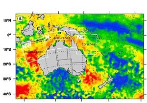
Sea-surface temperatures off northern Australia in the Indian Ocean, Arafura Sea and Coral Sea were unusually warm at the time, in places as much as 2 degrees C, the study notes: analysing 30 years of historic measurements, the study identified a general warming trend there of at least 0.2 degrees C per decade.
“If the observed warming trend in the sea-surface temperatures continues, this result suggests that future La Niña events are more likely to produce extreme precipitation and flooding than is present in the historical record,” says Dr Jason Evans, of the UNSW Climate Change Research Centre. Dr Evans led the study, to be published in the journal Geophysical Research Letters, with a French co-author, Dr Irène Boyer-Souchet.
“If the sea-surface temperature increases can be attributed to global warming, then the probability of La Niña events producing extreme precipitation responses similar to December 2010 will increase in the future.”
The researchers caution, however, that this was the strongest La Niña event during the satellite record and that equally extreme events may have occurred before the satellite record began.
The extreme December rains – coming after a wet spring - produced nine floods that affected almost 1,300,000 square kilometres of land, caused billions of dollars in damage, led to the evacuation of thousands of people, and resulted in 35 deaths.
La Niña conditions in the Pacific Ocean are well known to enhance Queensland’s rainfall. The heaviest falls occurred between December 23 and 28, 2010, when a moist easterly airflow covered most of Queensland and Cyclone Tasha made landfall south of Cairns. Large parts of eastern Queensland received more than 100 mm of rain and several stations set all-time daily records, with some receiving around 300 mm in one day.
Modelling reconstructions showed that on December 14, a low-pressure centre formed off the north-west coast of Australia and moisture-laden air was carried east to New Guinea then south into Queensland, contributing directly to heavy rain between December 23 and 26.
Media contacts:
Jason Evans, 02 9385 7066 |
UNSW Faculty of Science media liaison Bob Beale, 0411 705 435