UNSW team helps in China earthquake
UNSW engineers are using detailed satellite assessment to assist with the recovery from an earthquake which hit China on May 12, killing more than 60,000 people.
Published on the 30 May 2008


UNSW engineers are using detailed satellite assessment to assist with the recovery from an earthquake which hit China on May 12, killing more than 60,000 people.
Researchers from the University of New South Wales are providing Chinese authorities with highly detailed satellite assessment of the area devastated by the earthquake which hit China on May 12, killing more than 60,000 people.
Radar satellite surveying of the ground movements in the quake zone by the InSAR (Synthetic Aperture Radar Interferometry) team at UNSW's School of Surveying and Spatial Information Systems and the Cooperative Research Centre for Spatial Information is giving the China Earthquake Authority information about the level of damage from the magnitude 8.0 earth tremor.
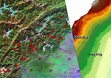
The UNSW/CRCSI InSAR team was among the first in the world to generate a ground displacement map of the quake zone, showing upheavals in the Earth's surface of up to 5m. The UNSW team is also the only group supplying information to Chinese authorities.
Head of the School of Surveying and Spatial Information Systems, in the Faculty of Engineering, Professor Chris Rizos, said after the race began to rescue survivors, the UNSW team joined a global race to determine the size of the quake-induced movement, important for assessing the degree of landslips and other dangers, and assisting the recovery mission.
"Our InSAR team joined the race, together with other InSAR teams including those from Oxford University, Stanford University, Harvard University and the US Geological Survey, in order to generate the first ground displacement map for the quake using satellite radar interferometry, a remote sensing technique which can be used to assess damage, support the rescue missions and better understand the quake event itself," Professor Rizos said.
"Our team worked around the clock as soon as the Japanese ALOS satellite successfully acquired imagery in the early morning of 20th May. We released our results at noon on 21st May to the Chinese authorities.
"We are one of the first to get such results, thanks to the close collaboration with Japan's Earth Remote Sensing Data Analysis Center (ERSDAC) and the Kochi Women's University of Japan."
The high-resolution map generated from analysis of satellite radar images shows ground lifting by up to 5m in areas affected by the quake.
Associate Professor Linlin Ge, who led the UNSW team, said the China Earthquake Authority could overlay the image provided by UNSW onto satellite photos to assess damage around buildings or bridges.
"The larger the ground deformation, the more likely the structures will be damaged," he said.
Associate Professor Ge, who also holds the inaugural position of Professor of Spatial Information at UNSW and the NSW Department of Lands, said InSAR technology has the potential to predict aftershocks and landslides once a comprehensive "constellation" of radar satellites is established to provide regular coverage. At present, the ALOS satellite which generated the pictures of the quake zone orbits Earth once every 46 days.
More regular InSAR analysis could pick up deformation in ground formations before aftershocks occurred, said Associate Professor Ge, however at present there are "less than a handful" of satellites capable of providing the required radar images.
Associate Professor Ge's work received coverage in the Sydney Morning Herald on Friday, May 30.